
*UPDATED 5 JULY – NEW BC, AB, AND SK WILDFIRE & DROUGHT SITUATION*
I’m closing the windows again to keep the cool in and the heat out. It’s another hot, sunny day on the west coast, and while it’s nice to have great weather, it’s scary to see the landscape dry to a crisp and our water supplies dwindle.
We’re used to hearing about the California drought – and it’s an important topic with implications not just for water supply and water security in California itself, but for larger issues such as regional agricultural policies, fisheries, power generation, continent-wide food supply, and more. Thing is, while the drought is particularly bad in California, it is by no means limited to that single state. Both Washington and Oregon have declared drought emergencies, and the dry conditions don’t stop at the 49th parallel. Western Canada is dry and hot after weeks of record high temperatures and record low precipitation, following close on the heels of a warmer and drier than average winter.
Researchers are linking these abnormal conditions to a couple of factors. A shift in the jet stream has led to what Mashable’s Andrew Freedman calls a ‘zombie’ weather system: a static, blocking high pressure ridge that routes hot, dry air over the west with a corresponding low pressure trough in the east. This ridge has led to a long term lack of storms and ocean mixing, which may have helped form a warm ‘blob’ off the west Coast, where Pacific sea surface temperatures are about 2°C above normal, and which has brought aquatic species farther north than they’ve been previously seen.
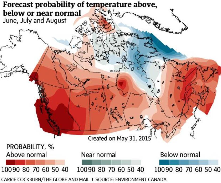
As a result of these factors, Environment Canada is predicting a high probability of higher than average temperatures across the west this summer, which will only exacerbate the water situation.
 I thought we’d take a quick tour of the Canadian west to see what’s happening under these conditions (note my coverage is more detailed for BC, as that’s what I keep track of most closely).
British Columbia
The provincial River Forecast Centre’s 15 June report showed province-wide snowpack at ~5% of normal, with streamflow in some regions, particularly the South Coast and Vancouver Island, more similar to July or August than to June conditions. They warn of the risk of extreme low streamflow later this summer. UPDATE 5 JULY: as of 3 July, the BC Government has declared that Vancouver Island is in a Stage 4 drought, and has closed all streams to recreational fishing due to low streamflow and high water temperature. Andrew Campbell, a fisheries biologist working up-Island, sent me this picture of sockeye salmon dying in the Sproat River, near Port Alberni.
 This past weekend, 64 temperature records were broken across the province, with experts predicting June of 2015 to be BC’s hottest in 119 years. It’s also on track to be the 4th driest year on record in Vancouver, which also follows on from one of the driest Mays on record. Here in the Cowichan Valley, we saw ~11% of normal precipitation for the month of June.
The wildfire risk is high to extreme across much of the province, though the wildfire situation hasn’t exploded…yet.
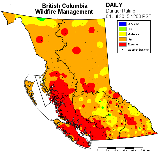
 UPDATE 5 JUL: as of today the wildfire situation has become more critical, with 33 new fires having started in the past couple of days on the Island and in both the southern and northern Interior. Looking at the wildfire danger rating map as of 4 July (below), most of the province is now at high to extreme fire danger rating, compared to the map from 30 Jun (above).
 Given the high fire risk, many regions have a campfire ban in place, with some municipalities cancelling today’s Canada Day fireworks and implementing serious water restrictions. UPDATE 5 JUL: The entire province is now under a campfire ban.
The Comox Valley Regional District is going to stage 3 water restrictions on Friday, as the low water levels are potential problematic for both power generation and fish habitat. If the low flows persist (as predicted), BC Hydro may have to dredge the Puntledge River to increase flow to the turbines for power generation, with subsequent downstream turbidity issues and boil water advisories. Similar issues are plaguing BC Hydro at Campbell River’s John Hart Dam, where low flows mean they generated electricity at only 25% of capacity last weekend. Meanwhile the Cowichan Valley Regional District remains at Stage 2 water restrictions., and the River Forecast Centre issued low streamflow advisories for the Chemainus, Cowichan and Koksilah Rivers last Monday.
Alberta & Saskatchewan
This year’s Rocky Mountain snowpack was relatively low – and it disappeared one to one and a half months earlier than usual, with impacts on water flow to both sides of the Continental Divide. Soil moisture levels in central Alberta are at a 50 year low, due a combination of low precipitation and high temperatures, which increases evaporation. Farmers are hoping desperately for rain to help their crops, given what Alberta Agriculture describes as “70 days of quite unusually dry spring conditions.” Saskatchewan has also officially declared a drought, with its driest March to June period on record, and air temperatures on the rise to approximately 10 degrees above normal.  The wildfire risk in Alberta is focused largely on the northern part of the province, with more than 25 large, out of control wildfires currently burning. UPDATE 5 JULY: there are currently 115 active wildfires in Alberta, with 45 of them burning out of control – mainly in the Fort McMurray and High Level region.
 117 wildfires are currently burning in Saskatchewan. In northern Saskatchewan, wildfires have driven thousands of people from their homes and are affecting air quality across Alberta, Saskatchewan and Manitoba. The fires in northern Alberta and Saskatchewan are starkly visible from space, as featured on NASA’s EO site. UPDATE 5 JULY: almost 8000 people have now been evacuated, and are being shipped to Canadian Forces Base Cold Lake in Alberta for emergency shelter and care. The fire has reached the airport at the town of La Ronge. The Saskatchewan government issued an update on the situation yesterday at 1pm.
 Northwest Territories & Yukon
The Northwest Territories saw record high drought levels and record wildfire activity in 2014, and 2015 isn’t looking much different. Officials expect the drought code to rise above the record highs of 2014, with corresponding increases in wildfire activity – which are already underway. Of particular concern is that ten of this year’s fires are holdovers from last year – that have never stopped burning.
The Yukon currently has 107 active fires across the territory, with more than 25 classified as out of control. BC has sent firefighters to help out. The forest fire risk is highest in the southern portion of the territory, at the border with BC.
————————
Consider that I’m writing this on July 1st, not the middle of August, and you start to wonder what’s in store for the rest of the summer. I’m glad we installed low flow toilets last year, and practice other water conservation methods, but am not sure how much it’s all going to help as the drought deepens.

Criminey.
Yeah, I’m not sure people realize how serious it is…
Very interesting. That map is way off about southern Ontario. It’s unusually cool and very wet out here so far. I sure hope the Island gets a bit of rain pretty soon.